Meramec River
Red Ribbon Area
Only flies and artificial lures are permitted, soft plastics specifically excluded. Daily limit is 2 trout at least 15 inches long.
I offer guided fishing trips on this river. My ability to earn a living at this is the only reason free information like you're finding on this page exists, so help a brother out. Book a trip or help me spread the word. Thanks! Click HERE to visit my guide service page.
The Meramec River near Maramec Spring Park is a favorite destination of hardcore fly fishermen and recreational floaters from all over the state. The trout area stretches from the Highway 8 bridge all the way down to Scotts Ford -- a little more than 8 miles of fishable water. It also includes the portion of Dry Fork Creek downstream from the elevated cable crossing. In fact, the confluence of Dry Fork and the Meramec -- about a mile below the park -- is a favorite fishing location commonly referred to as the "piles", a series of downed trees that form some wonderful river structure.
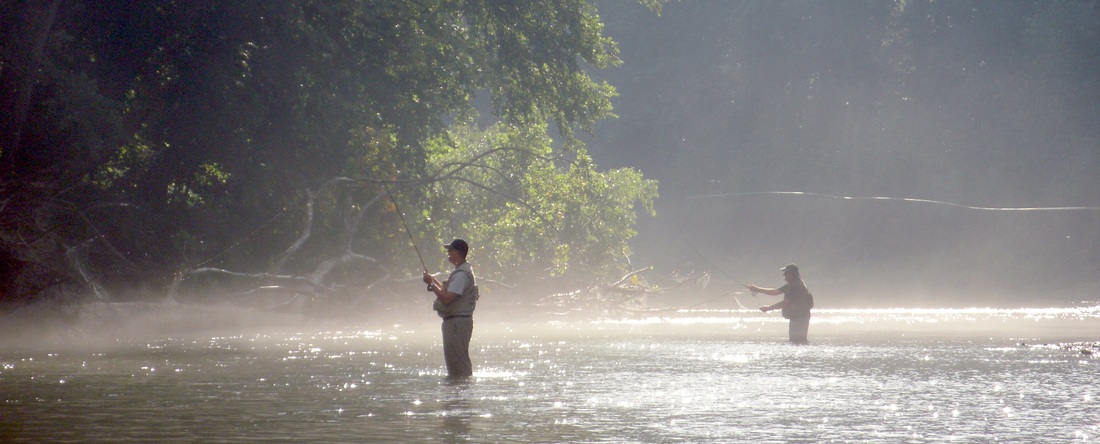
Access to the best fishing areas can be tricky, which is actually what makes the fishing pretty darn good. Without easy bank access, only serious fishermen make the effort to get to where the fish are, so folks like us will often be there alone. Even when it's "crowded", you can usually fish all day and only see a few other fishermen.
There is easy access at the Highway 8 bridge, about 2 miles upstream from where Maramec Spring dumps into the river. The next access point is at the trout park. Pay your $5 to park, and walk down to the confluence below the swinging bridge. There is easy bank access to the upstream side, but most fishermen will go downstream toward the bigger water. There is a rough trail along the Northwest bank of the river, which seems to be the easiest path. Some also choose to cross the river upstream of the spring branch and work their way downstream from the opposite bank while casting streamers, spinners, little crankbaits and such -- usually a decent strategy.
NOTE: if you plan to keep your fish and enter from the park, you'll need to purchase a daily fishing tag from the park store -- it's required to possess the fish, regardless of where they were actually caught. Also, do not assume that you can combine your fish from the park and the red ribbon area. If you are seen fishing the red ribbon area and are caught with more than 2 fish or any fish under 15", you will be cited for poaching. Same thing if you're caught in the park with your 4-fish limit plus your 2-fish limit from the red ribbon area. That's a big NO NO! Remember, it's where you are POSSESSING the fish rather than where you caught them.
The third and fourth access points are known affectionately as "Cardiac Hill" and "Suicide Hill", and many believe these two points provide access to the best fishing areas. To get to these access points, you can do two things. Option #1: Traveling South from I-44 through St. James like you're heading to the park, turn left when you see the "Boys and Girls Town" sign onto Boissilier Road / Hwy DD. You'll eventually find you're on County Road 3620, which will soon begin driving along side of Dry Fork Creek. At the "Y" in the road, lean right to stay on CR 3620. Then turn right on Besmer Rd, a little dirt road that is occasionally not marked. Perhaps some possessive local trout fishermen trying to protect their "secret" spot? If you reach Highway KK, you've gone too far. If you're travelling from the St. Louis side of things, here's a better option. Take the Rosati exit from I-44 (exit #203). Turn right on the south outer road to Rosati. Take Hwy KK south through town for 3 miles or so. When KK curves sharply left, you find Brennan Rd. / CR 3620 on your right in the crook of that curve. Follow that road for a bit and turn left onto Besmer.
Once on Besmer, the first parking area you'll come to is "Cardiac Hill". Drop down to the gated gravel road by way of a rough trail from the corner of the parking area, walk down to the fields, cut across the field and pick up the trail again on the other side. The river is just through that last stand of brush. The second parking area is "Suicide Hill". Put your gear in a daypack, because you'll need both hands getting down safely.
The last access point is Scott's Ford. If you get back on KK heading East, turn right on Thurman Lake Rd. It will take you right to the water. Yes, the trout fishing can be very good upstream from this point, but usually non-existent downstream, depending on the season. However, the smallmouth fishing can be fantastic both upstream and downstream.
The Meramec River near Maramec Spring Park is a favorite destination of hardcore fly fishermen and recreational floaters from all over the state. The trout area stretches from the Highway 8 bridge all the way down to Scotts Ford -- a little more than 8 miles of fishable water. It also includes the portion of Dry Fork Creek downstream from the elevated cable crossing. In fact, the confluence of Dry Fork and the Meramec -- about a mile below the park -- is a favorite fishing location commonly referred to as the "piles", a series of downed trees that form some wonderful river structure.
Access to the best fishing areas can be tricky, which is actually what makes the fishing pretty darn good. Without easy bank access, only serious fishermen make the effort to get to where the fish are, so folks like us will often be there alone. Even when it's "crowded", you can usually fish all day and only see a few other fishermen.
There is easy access at the Highway 8 bridge, about 2 miles upstream from where Maramec Spring dumps into the river. The next access point is at the trout park. Pay your $5 to park, and walk down to the confluence below the swinging bridge. There is easy bank access to the upstream side, but most fishermen will go downstream toward the bigger water. There is a rough trail along the Northwest bank of the river, which seems to be the easiest path. Some also choose to cross the river upstream of the spring branch and work their way downstream from the opposite bank while casting streamers, spinners, little crankbaits and such -- usually a decent strategy.
NOTE: if you plan to keep your fish and enter from the park, you'll need to purchase a daily fishing tag from the park store -- it's required to possess the fish, regardless of where they were actually caught. Also, do not assume that you can combine your fish from the park and the red ribbon area. If you are seen fishing the red ribbon area and are caught with more than 2 fish or any fish under 15", you will be cited for poaching. Same thing if you're caught in the park with your 4-fish limit plus your 2-fish limit from the red ribbon area. That's a big NO NO! Remember, it's where you are POSSESSING the fish rather than where you caught them.
The third and fourth access points are known affectionately as "Cardiac Hill" and "Suicide Hill", and many believe these two points provide access to the best fishing areas. To get to these access points, you can do two things. Option #1: Traveling South from I-44 through St. James like you're heading to the park, turn left when you see the "Boys and Girls Town" sign onto Boissilier Road / Hwy DD. You'll eventually find you're on County Road 3620, which will soon begin driving along side of Dry Fork Creek. At the "Y" in the road, lean right to stay on CR 3620. Then turn right on Besmer Rd, a little dirt road that is occasionally not marked. Perhaps some possessive local trout fishermen trying to protect their "secret" spot? If you reach Highway KK, you've gone too far. If you're travelling from the St. Louis side of things, here's a better option. Take the Rosati exit from I-44 (exit #203). Turn right on the south outer road to Rosati. Take Hwy KK south through town for 3 miles or so. When KK curves sharply left, you find Brennan Rd. / CR 3620 on your right in the crook of that curve. Follow that road for a bit and turn left onto Besmer.
Once on Besmer, the first parking area you'll come to is "Cardiac Hill". Drop down to the gated gravel road by way of a rough trail from the corner of the parking area, walk down to the fields, cut across the field and pick up the trail again on the other side. The river is just through that last stand of brush. The second parking area is "Suicide Hill". Put your gear in a daypack, because you'll need both hands getting down safely.
The last access point is Scott's Ford. If you get back on KK heading East, turn right on Thurman Lake Rd. It will take you right to the water. Yes, the trout fishing can be very good upstream from this point, but usually non-existent downstream, depending on the season. However, the smallmouth fishing can be fantastic both upstream and downstream.
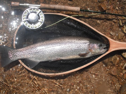
The most popular stretch of this river is the section between Suicide Hill and the Piles. During the warmer months, every riffle and pool will hold plenty of fish, and pretty much every decent hole will hold a 20-inch fish (yes, really). And, for the purist out there, the fish will usually eat like you want them to. Pheasant tails, hare's ears, copper johns, stoneflies, elk hair caddis, cracklebacks, and the such are all winners down here at times, although the dry fish fishing is hit or miss. There's also a fantastic scud population. Streamers, spinners and little crankbaits also often produce. However, you still have to be a problem- solver. They don't bite on everything all the time (duh), and you will have to walk or float to find the best spots.
The trickiest thing about this river is that the seasonal migration of the fish will drive you crazy. Browns spawn in the fall, and the rainbows are really confusing. Half of the hatchery stock will spawn in the fall, and the other will spawn in the spring. And if that's not confusing enough, there are also some mature wild rainbows that escape from locations like Blue Springs Creek, and they'll tend to spawn during the winter, due to their McCloud blood. AND, if one strain is spawning, the others will often follow the same migration patterns for no good reason. If you can wrap your brain around all that and can maintain a good idea of where the fish are and why, you're winning half the battle. Couple that with the knowledge that rainbows and smaller browns mostly eat drifting bugs, while mature browns and whopper rainbows tend to be meat eaters (i.e. minnows, crayfish, etc.), and you should be able to catch fish almost any time of the year.
Be careful on this river. Not only is the Meramec River a major drainage, Maramec Spring is fed by a multitude of losing creeks, meaning creeks that actually lose flow to the spring recharge pool as they travel. Therefore, every time it rains, the spring's output jumps up big time. The average flow is 96 million gallons per day, but it's 3 or 4x that amount on occasion. Coupling that with runoff, a decent overnight storm can raise the river level by a foot, increasing the current to dangerous speeds, making the river unwadeable and putting the fish off their feed. If you brave the increased flow, you'll often be wasting your time. Avoid a wasted trip by checking the river level before heading out. If the Meramec is up, try the upper Current River -- it doesn't fluctuate nearly as much.
That said, Meramec flooding is one of the reasons I love this river. Being a shifting substrate river (gravelly instead of bedrock), a good flood changes the river. That means you have to figure it out over and over again. Since I'm easily bored, this is PERFECT for me!
| woodson_k_woods_ca_map.pdf |